According to the forecast of the National Center for Hydro-Meteorological Forecasting, storm No. 15 will strengthen to level 10 in the next 24 hours, gusting to level 13, an increase of 2 levels compared to 7:00 a.m. this morning.
The area from Quang Tri to Lam Dong needs to proactively respond to storms.
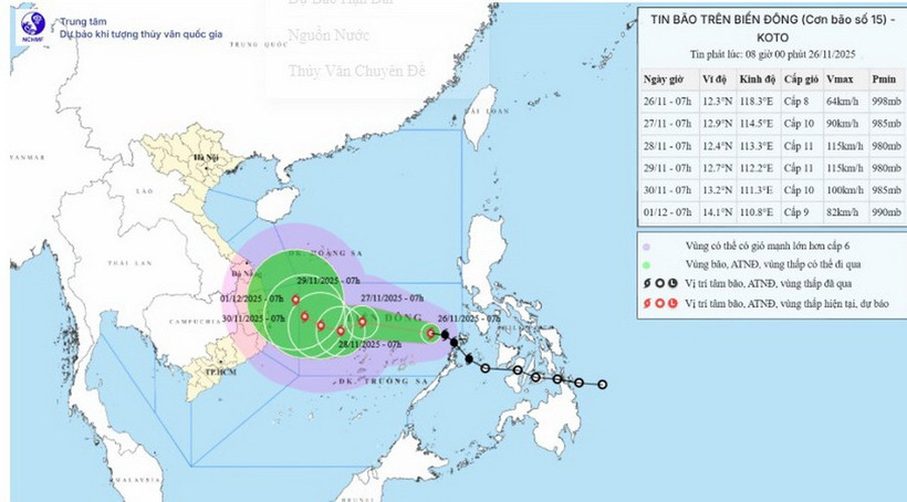
Specifically, at 7:00 a.m. on November 26, the center of the storm was at about 12.3 degrees North latitude; 118.3 degrees East longitude, about 440km east of Song Tu Tay island. The strongest wind near the center of the storm was level 8 (62-74km/h), gusting to level 10. The storm was still moving northwest at a speed of about 25km/h.
As of 7:00 a.m. on November 27, the storm was in the central East Sea, about 170 km north of Song Tu Tay Island, moving west-northwest at a speed of about 15-20 km/h and likely to strengthen. The strongest wind was level 10, gusting to level 13. The affected area was the central East Sea (including the sea area north of Truong Sa special zone). Disaster risk level 3.
At 7:00 a.m. on November 28, the storm in the central East Sea, about 160 km northwest of Song Tu Tay Island, moved west-southwest at a speed of about 5-10 km/h and continued to strengthen. The strongest wind was level 11, gusting to level 14. The affected area was the central East Sea (including the sea area north of Truong Sa special zone). Disaster risk level 3.
As of 7:00 a.m. on November 29, the storm was in the western sea area of the central East Sea, about 270 km west-northwest of Song Tu Tay Island, moving west-northwest at a speed of about 5 km/h. The strongest wind was level 11, gusting to level 14. The affected area was the western sea area of the central East Sea (including the northwest sea area of Truong Sa special zone). Natural disaster risk level 3.
From the next 72 to 120 hours, the storm will move northwest at a speed of about 5km/h and gradually weaken. Due to the impact of the storm, the central area of the East Sea (including the sea area north of Truong Sa special zone) will have strong winds of level 6-7; the area near the eye of the storm will have strong winds of level 8-10, gusts of level 13; waves 4-6m high, the area near the eye of the storm will have 6-8m; the sea is very rough. Warning: During November 27-28, the central area of the East Sea (including the sea area north of Truong Sa special zone) is likely to be affected by strong winds of level 11, gusts of level 14, waves 7-9m high, and rough seas. Ships operating in the above-mentioned dangerous areas are likely to be affected by storms, whirlwinds, strong winds, and big waves.
In response to the above developments, on the morning of November 26, the Head of the National Civil Defense Steering Committee issued Document No. 34/CD-BCĐ-BNNMT to the People's Committees of coastal provinces and cities from Quang Tri to Lam Dong; the Ministries of National Defense, Public Security, Agriculture and Environment, Construction, Industry and Trade, Foreign Affairs, Science and Technology, Health, Education and Training; Vietnam News Agency; Vietnam Television, and Voice of Vietnam on responding to storms in the East Sea.
To proactively respond to storm No. 15 in the context that the Central region is continuing to overcome the consequences of historic rains and floods that have caused serious damage in recent times, the National Steering Committee for Civil Defense requested that provinces and cities in the South Central region continue to focus on overcoming the consequences, restoring production and business, and stabilizing people's lives after the recent historic rains and floods according to Official Dispatch No. 227/CD-TTg dated November 23, 2025 of the Prime Minister; prepare response plans for storm No. 15 and subsequent natural disasters.
Ministries, branches and localities closely monitor the storm's developments; strictly manage vessels going out to sea; organize counting and notify owners of vessels and captains of ships and boats operating at sea of the location, direction of movement and developments of the storm so that they can proactively avoid, escape or not move into dangerous areas.
Dangerous areas in the next 24 hours: latitude 10.0-14.5 degrees North; East of longitude 114.0 degrees East (dangerous areas are adjusted in forecast bulletins); ready forces and means to deploy rescue work when there is a situation.
Ministries and branches, according to their state management functions and assigned tasks, proactively direct and coordinate with localities to respond to storms.
Vietnam News Agency, Vietnam Television, Voice of Vietnam, the coastal information station system and mass media agencies from central to local levels should increase information about the storm's developments to authorities at all levels, owners of vehicles operating at sea and people to proactively respond.
The above units organize serious duty and regularly report to the National Civil Defense Steering Committee (through the Department of Dyke Management and Natural Disaster Prevention and Control - Ministry of Agriculture and Environment)./.